
 Live Slope Map
  Samnaun Mountain Railways
  Livecams
  WhatsApp
  Events
  Vouchers
 TRANSALPINE RUN 2019 4. Etappe

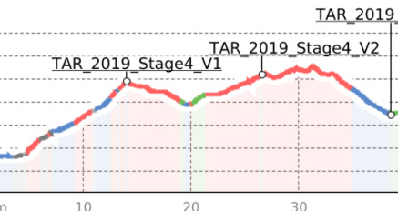
Distance 46.3 km, Elevation gain 2895 m, Elevation gain 1868 M
After the early start in Landeck (809m), we run via Hochgallmigg (1218m) and the Landecker Skihütte (1766m) to the Fisser Joch (2432m). This is where the first aid station is located. From there it goes along the Komperdell to the Kölner Hütte (1965m). Via the Böderweg and along the Böderbach, the route leads to the Arezjoch (2587m), where the second aid station is located. Then we get through alpine terrain up to the Ochsenscharte (2787m), our highest destination for the day, before we go via the Stierhütte (2290m) to the Swiss border (1725m) (food). From - here mostly keeping the altitude - the path leads us to the finish in Samnaun (1841m).
Details
Verantwortlich für diesen Inhalt PLAN B event company GmbH.
Dieser Inhalt wurde automatisiert übersetzt.

Diese Webseite nutzt Technologie und Inhalte der Outdooractive Plattform.